Community

It’s important to understand weather’s impact

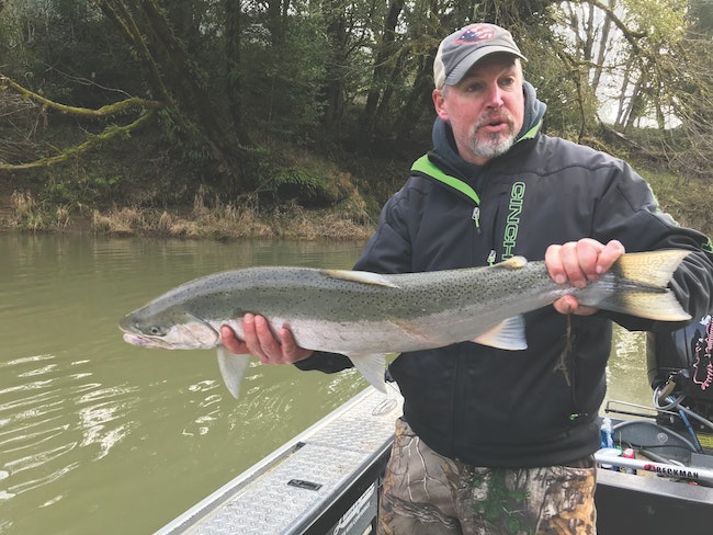
FRANK ARMENDARIZ/PHOTOPhill Strader of Glide is about to release a wild steelhead from the Umpqua River that I caught last February. The presence of an adipose fin required that this steelhead buck be released.

A couple of Pacific storms came onshore last weekend, bringing strong winds along the Oregon coast and a good drenching rainfall to the western portion of the state. It was a good cleansing storm that blew the last of the leaves from the trees lining the banks of our coastal waterways. 

The rain also caused most coast rivers to rise sharply, flushing debris and sediments that collect through the summer and fall along the river bank and riverbed. The tea-colored water is common to coastal rivers in the fall, now turning an emerald green … and more rain is coming.

On the rush of water, Oregon rivers are famous for its runs of winter steelhead will light up from the reflection of chrome. Rivers that include the South Fork of the Coquille, the Umpqua, the South Umpqua and the lower Umpqua tributary, Smith River. The Siuslaw River’s largest tributary, Lake Creek, the Alsea River and finally the Siletz River. Any day now, you will find both hatchery-raised and broodstock fish that you can tag and take home. Some of these rivers also hold strong runs of hard-fighting wild steelhead that are especially fun to catch but in most cases have to be released.

To our north and south, there are also dozens of other rivers that will soon have steelhead too. But the distance makes them a better multiple-day destination. The Siletz can be a long haul from the valley but the Siuslaw, Lake Creek and the rivers of the Umpqua system are convenient and fairly easy to reach from the southern Willamette valley for a single day of fishing.

I describe how the weather affects the fishing conditions in nearly every report because it is elemental to being a successful angler. As elemental as your selection of gear, lures or baits. (A good handle on the weather can also keep you and your family safe in the winter.) In Oregon it’s either dry or wet, that in general creates three types of river conditions. High river levels; usually after heavy rain, which can be unsafe to boat on but could be a good bank fishing day. Followed by ideal or “perfect river levels”; that every angler dreams of. “A stream with the perfect color and volume and a convergence of angler and fish.” Finally, “low water”; a condition that some anglers find the most challenging and frustrating of the three, particularly when you can see steelhead in the low water but can’t get them to bite. 

On a short coastal river you could encounter all those conditions within a single week. So I can’t overemphasize that a quality day of winter steelhead fishing is in your ability to discern the stream condition you will encounter before you arrive on the riverbank to fish. Your gear needs to be appropriate for the river levels. Coastal streams are for the most part relatively short and can rise sharply after a heavy rain. After eons, steelhead have adapted to those conditions, while many anglers remain challenged by the fluctuations. The lures that worked great when the river was high are not so good as the levels fall. So you like the fish, you too need to adapt.

In general, as the coastal watersheds become saturated with winter rains. Small rivers and streams that were essentially not navigable in the summer now maintain levels suitable for boating and excellent for fishing all winter. The current stage of dozens of rivers in Oregon can be found on the National Oceanic Atmospheric Administration (NOAA/Oregon/river levels) including the ones I have mentioned above. In addition to the current river levels NOAA also provides a prediction based on its weather reports, of what the river levels could be several days out. The information is vital to winter steelheaders who can interpret the data and relate it to the real world. 

FRANK ARMENDARIZ/PHOTOThe Alsea River at 5 feet is the perfect river level for bank and drift-boat fishing.

So what does the gage mean and how do you apply the information to be a successful steelheader? What are the “perfect river levels” to and how do you figure it out? Years of experience can teach you when your favorite river comes into shape, but I would suggest you visit my website, rivertrailoutfitters.com/riverlevels. I have been collecting river-level data for 30 years. The information has been “river guide approved,” reprinted dozens of times in angling magazines and broadcasted on several outdoors TV shows because of its accuracy. 

Next to every river I have listed you will find three values. From left to right, the first value is the overview of a range of river levels on which good angling and boating takes place. For instance, on the Alsea River where the river gage is at Tidewater. That range is between 3.5 and 7.0 feet. Below 3.5 ft. boating is not practical but might be good for bank fishing. Above 7 feet the river essentially blows out and becomes unsafe to boat, but again could be good for the bank anglers. Within those ranges is a “sweet spot” that boaters should take note of and what I call “the perfect river levels.” For the Alsea that sweet spot is when the river gage at Tidewater reads 4.5 to 6.3 feet. Finally, the last value is what I refer to as the “plucking levels.”

On the Alsea that level is 6.5 to 8 feet. Above that height the river begins to flood over it banks becoming unsafe to boat. 

There are about 40 rivers and river segments listed on my Perfect River Levels page, nearly every coastal river that has steelhead in our region is on my website and there is no fee or obligation to use the information. In a few weeks I’ll explain how to select the appropriate tackle and lures to effectively fish any river at a variety of stages.

Email: [email protected]

Instagram


View this profile on Instagram


The Chronicle (@thechronicle1909) • Instagram photos and videos