Outdoors

THE OREGON DUNES

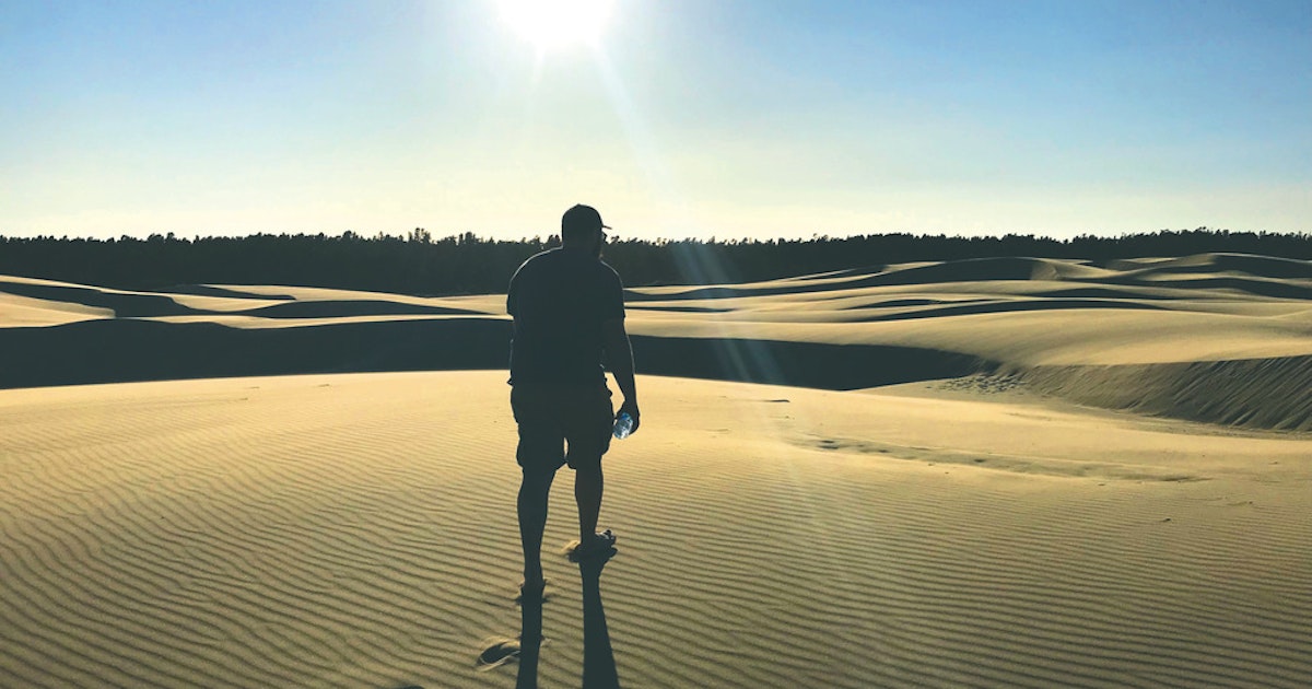
The dunes remain a place where solitude and simplicity can still be found. Frank Armendariz/The Chronicle

FLORENCE – The Oregon dunes began to form about 100,000 years ago and are now among Oregon’s oldest geological features.
To add a little perspective, 100,000 ago was about the time the Cascade Mountain peaks, after millions of years of volcanic activity, had reached about the height they are today. The 400,000-year-old cinder cone that would grow to become Mount Mazama was still growing. The massive volcanic eruption that created Crater Lake was more than 90,000 years from happening, and the great Missoula floods that shaped the Columbia River Gorge were still about 85,000 years off.
But unlike the violent floods, volcanic and tectonic events that created those stunning formations and others in Oregon, the dunes that line a portion of far west Lane County, shared with Douglas and Coos Counties, were literally formed one grain of sand at a time.
It wasn’t until about 7,000 years ago that the Oregon dunes began to reach about the size they are today.
The dunes are surely the beneficiaries subduction zone activities that has lifted the coast mountains, exposing rock that is ideal for creating sand. Coastal currents also play a role, but not one single event can be credited with their formation – other than time and, over the eons, the movement of sediments down the Siuslaw, Umpqua and Coos Rivers.
The dunes are in a bit of trouble right now, mostly from invasive plants that tend to hold the sand in place and not allow it to drift. But there is a lot of sand still out there; geologists tell us that the deposits of sand along the beaches adjacent to the dunes are up to 400 feet deep in some locations. With proper stewardship they should be there for hundreds more years.
One of our state’s most visited attractions, the Oregon dunes were first proposed for preservation in 1963. But wasn’t until 1972 that Congress set aside the 32,186 acres of land which encompasses the entire dune area as the Oregon Dunes National Recreation Area. The set-aside land, about a 40-mile stretch, extends from the north bank of Coos Bay to the south jetty of the Siuslaw River. It is the largest coastal sand dune in the country.
On the north and south ends and in the middle at the Siltcoos access to the National Dunes Recreation Area are ”off-highway vehicle” (OHV) parks where motorized sand buggies and other sand vehicles can tackle some of the tallest dunes. At one time, about 90% of the dunes were open to OHV traffic but that access is now restricted to about 30% of the recreation area. The rest of the dunes is set aside for wildlife, hikers and wildlife viewing.
The most popular trail through the Oregon dunes begins at the National Oregon Dunes Overlook, which is about 10 miles south of Florence on Highway 101. There are two trail options that start at the Overlook. A one-mile hike (two miles round trip) takes you through the sand and directly to the beach. From the beach you can retrace your short journey back to the Overlook parking area. Or, trek south along the beach and continue on a 3.5-mile loop that will lead you through a range of coastal dune habitats. Both hikes are demanding but well marked and a rewarding effort.
A detailed map of the trail and other information can be found at: https://www.fs.usda.gov/recarea/siuslaw/recarea/?recid=42465.
At the National Dunes Overlook you will also find two fully wheelchair-accessible viewing decks. There is a wheelchair ramp leading to the upper deck; the ramp is wide and only mildly sloped. You can also reached the upper deck via an adjacent stairway. The lower viewing deck is at parking-lot level, where there is also an ADA accessible restroom, accessible parking lot and other refinements to facilitate folks of all abilities’ enjoyment of the site.
You will need a ”National Park park pass”; self-service pay kiosks are located at all the primary entrances to the recreation area, at $5 per day. You can also buy a permit online at: https://www.fs.usda.gov/main/siuslaw/passes-permits/recreation. A variety of applicable Forest Service permits are also available on the site.
Summer is the windy season in the dunes; the sand is dry, shifts under your feet and is harder to walk on. Parts of the coastal beaches are also closed off or restricted to aid the sand-nesting, endangered Plovers.
Fall and winter are better for exploring; aside from the winter storms that pass through, the wind is lighter and the rain firms the sand, making hiking less of a chore. The Oregon Dunes Recreation Area is managed by the Forest Service, but the beaches are patrolled by the Oregon Parks Division. Adjacent to the recreation area, each county that shares the sand also provide visitor accommodations for day use, campers, dune hikers and motorized riders.
I feel especially blessed that I have been able to see so much of Oregon; my work as a river guide has gifted me with some of our state’s most beautiful visual images. But the sand is like nowhere else – windswept, lonely at times and an opportunity to experience the type of solitude you can’t find in many places anymore. There is ”wilderness” within its expanse – something to cherish, worth protecting, sharing …
SAVE THE OREGON DUNES
The Oregon Dunes Restoration Collaborative (ODRC) released “Save the Oregon Dunes,” a seven-minute video that tells the story of one of the largest expanses of temperate coastal sand dunes in the world and how invasive plants threaten this enchanting landscape.
Watch it here: saveoregondunes.org/learn/saving-the-oregon-dunes/
Learn more about the ODRC and how to get involved by visiting SaveOregonDunes.org.

Instagram


View this profile on Instagram


The Chronicle (@thechronicle1909) • Instagram photos and videos