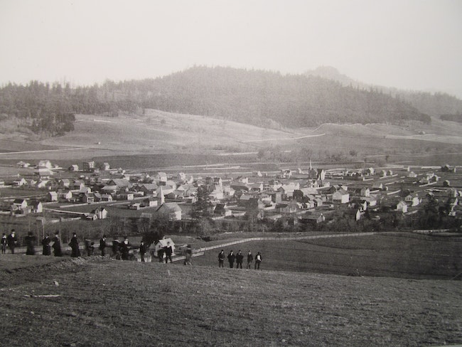

 PHOTOS PROVIDED/COTTAGE GROVE HISTORICAL SOCIETY The view of Cottage Grove from “The Hill,” circa 1900.
Mount David, a silent witness to Cottage Grove’s birth and growth, stands over our town.
It has served a variety of roles in the city’s history. An early water system had its reservoir there in the 1890s. Early photographers documented the town’s growth with panoramic views from its slopes.
One slick huckster used it to separate many citizens from their hard-earned cash. But mostly the bucolic hill came to be regarded as common space by Grovers, the perfect place for a walk, picnic, or just to pause and reflect.
Before settlers arrived and began to build what has become Cottage Grove, the local Kalapuya had numerous villages along the Coast Fork and Row rivers and the creeks that fed into them. One of their special and most sacred areas was this large hill that rises on the west side of the river.
While it’s been known by several names, we don’t know what the Kalapuya called it. But from the 881-foot bluff they revered the views, where on a clear day you can see the Cascades. The rock outcroppings on the southeastern face are one of the most sacred to the 14 bands of Kalapuya.
One of their creation stories describes a world made only of stone. There came down from the stone mountain a woman called Le-lu. This first woman carried two babies who she gave to a mother wolf to care for as she surveyed the world. As a result of her moving around, the world became green with grasses, trees, and water. This rock outcropping, along with others in the Willamette Valley, is considered a possible place where Le-lu first appeared, and so are held sacred. Even today the Kalapuya perform special ceremonies there.
In an acknowledgment of this cultural past, when a small subdivision was fitted along the southeast foot of Mount David, the City of Cottage Grove named the street Kalapuya Way. It was dedicated in a ceremony on Earth Day, 2000. The street roughly follows the old Native American path that became the wagon trail for the settlers. One lot in the subdivision has been withheld from development due to Kalapuya artifacts found during construction.
In 1850 John McFarland was making his way home to Missouri, after failing to strike it rich in the California gold rush. This was the year that Congress had passed the Oregon Donation Land Act, one of the most generous in history. From 1843-50, male settlers could claim 320 acres, 640 if married, (640 acres = 1 square mile). After 1850 the amount was halved. McFarland made two claims, one for himself and another for his cousin James. Having dealt with floods back home in Missouri, McFarland chose high ground, and most of the hill was in James’ claim. He headed back home to fetch James and they returned to make residency and improvements as required by provisions of the law to make their claim legal.
Known on maps as McFarland’s Butte, the old-timers just called it “The Hill.” The land stayed in the McFarland family for several generations and became known as Mount David, at some point, for David Green McFarland, who inherited the land along with his brother James, when the claimant cousins died in the 1880s.
David’s share included most of the hill and what became the neighborhood that lies between West Main St. and Mt. David. This subdivision, named in Lane County records as McFarland’s Addition, contains Ash, Birch, and Chestnut streets and is known to its residents as the Northwest Neighborhood. David McFarland’s house still stands, the big blue one, at the corner of Birch and N. River Rd.
Generations of McFarlands and early settlers lie in repose in the cemetery that bears the family name, at the foot of Mt. David. The earliest known burial dates to 1863, the latest was in 2012, when a McFarland descendant joined his family. Among the graves lie at least three Kalapuya who had been befriended by the McFarlands. One of the best remembered is “Old Mary” Spores, who along with her husband Bob had survived the diseases introduced by the settlers, which had devastated many of their tribesmen.
She did washing for the McFarlands and other families, helped in slaughtering, and was famous for making fine gloves of deerskin. She died in 1901 and Laura Knox McFarland had a headstone made for her which, unfortunately, has been destroyed by vandals.
The cemetery is owned by the Cottage Grove Historical Society and has been restored and maintained by volunteers. There is an interpretative area there describing the history of the Kalapuya and the McFarland family.
In contrast to quiet repose of the dead, was the roar of those nascent motorcycles that took on Mt. David in the early 1920s. Local enthusiasts joined with motorcyclists from Lane County in the Eugene Motorcycle Association in planning what became an annual event.
In 1923 about 2,000 spectators had converged on Cottage Grove from as far away as Grants Pass to watch the daredevils try to scale the 80% grade of Mt. David. They used the steep eastern face near where the Great Days Early Education center is now. The local Lions Club and American Legion were involved as the event grew to around 6,000 in 1926. It is not certain when the annual event sputtered out but it was no doubt a relief to the local Methodist minister who had petitioned the city council to divert motorcycle traffic away from its Main St. Bridge location during Sunday services.
At the same time motorcycles were bothering the Methodists, another man of the cloth hit town and used Mt. David to his advantage. Curiously enough he was also named David, former Christian Church pastor Rev. David Olsen. He showed up in town with some Rube Goldberg gadgets and some equally outlandish patter. He claimed to have looked around and discovered Cottage Grove was floating on a lake of oil. The twists and turns of this false prophet make great reading, but despite some spirited naysayers he managed to extract a tidy sum from local inhabitants, but as it turned out not a drop of oil.
On Nov. 9, 1923 a large group of investors and skeptics alike gathered on Mt. David to hear Rev. Olsen pray for a blessing of this undertaking. The drill, hung on the derrick that had been constructed over the summer, was set in motion and folks who had sunk their savings in this enterprise started to count the millions that would come in when they struck black gold.
When months of dry drilling and numerous pleas for more money and patience finally dried up the locals’ resources, the slick reverend concentrated on his other scam, excuse me, operation, up in Eugene. Eventually he slipped off from both locations, but eventually got caught and jailed in Canada.
 PHOTOS PROVIDED/COTTAGE GROVE HISTORICAL SOCIETY Some residents were duped into a financial scam in the 1920s, convinced there was oil under Mt. David. PHOTOS PROVIDED/COTTAGE GROVE HISTORICAL SOCIETY
His derrick stood another 10 years before blowing down in a windstorm. I am sure many were happy to have this bittersweet memory gone from view as they licked their financial wounds. Today there is a pit with the capped pipe in the middle that serves as a memorial to the many local dollars that went down that tube.
The Veatchs, another early family, acquired most of the mountain and used it for years to pasture sheep. This pastoral setting is what most locals treasured about this spot. Local history powerhouse, the late Marcia Allen, relates her memories of the mountain in a paper found in the Cottage Grove Historical Museum files. She called Mt. David “her best friend and babysitter” when she was growing up. She recounted the many hours she and friends spent on the mountain wandering, playing, and picking pie cherries and bouquets of wildflowers there.
This is indicative of the feeling that many had for this place. Although it was privately owned it had become, in the eyes of the locals, viewed as common space. Free to use and enjoy, a retreat to walk to, close to town, a quick escape.
The end of this happy situation came when the property changed hands and the new owners had a different vision of how to use the mountain. Bulldozers and “No Trespassing” signs shocked Grovers who, for generations, had considered Mt. David their backyard.
Instead of accepting this as progress, many locals passionately joined together to see what they could do about it.
This story will continue next week tracing the history of how at least four different groups rallied to try and save Mt. David for the common good. These groups became known as “The Friends of Mt. David.”
Read Part 2 here
Read Part 3 here
Email: [email protected]