 ANDY NELSON/POOL PHOTOGRAPHER
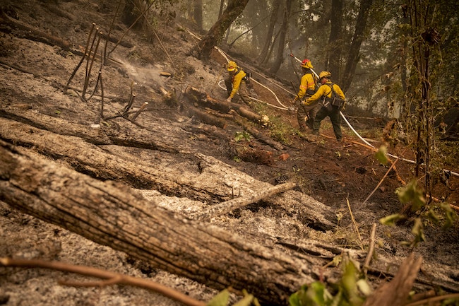
Firefighters faced an uphill battle while trying to contain the Holiday Farm Fire this past week.
A week after its first spark in the evening of Sept. 7, the Holiday Farm fire has burned 166,573 acres, while a million acres burn around the state.
By press time Tuesday, the Holiday Farm Fire was 6% contained. Creswell and Cottage Grove were not in evacuation zones, while parts of east Springfield were issued levels 1 and 2 evacuation notices.
The Lane County Sheriff’s Office reported one person found dead in the Holiday Farm rubble, with other deaths expected. The Oregon State Fire Marshal’s Office and an 80-person Urban Search and Rescue team have been looking for anyone who is unaccounted for.
Operations related to mass fatalities management on Tuesday consolidated to a mobile morgue to help with timely identifications and the recording of accurate mortality data, according to Oregon Health Authority.
Outside of the evacuation zone, the fire has been choking the rest of the valley with smoke and creating hazardous air conditions. Last week, the valley clocked air quality index values into the 700 range on the air-quality monitoring site PurpleAir, greatly exceeding the scale’s maximum value of 500, or “hazardous.”
 Lane County Fire Map, found at the Lane County website and lcgisorg.maps.arcgis.com
Oregon Health Authority (OHA) officials said that relief from harmful air quality may not come until the weekend, when wind off the coast is expected to improve conditions.
Lane County Emergency Management and public safety partners have been assessing the damage in the safe spots.
There are 1,018 structures within the fire perimeter; as of Tuesday, the team assessed about 30% of the structures in the fire area, including commercial buildings, residences and outbuildings. The team started at the eastern edge of the fire in the community of Rainbow and have been working west down the Highway 126 corridor.
As of Sept. 15, some 315 structures have been identified as being destroyed by the fire; 14 with damage; and 102 with no damage. The team expected to assess structures in the community of Blue River Tuesday.
Volunteers have come out in droves. St. Vincent de Paul, United Way of Lane County and the Lane County Emergency Operations Center partnered with the grassroots organizers of the donation center currently operating at Silke Field in Springfield to provide a long-term drop-off and sorting location at 2699 Roosevelt Boulevard in north Eugene.
 ERIN TIERNEY/THE CHRONICLESeavey Loop was closed this week, limiting access to Mt. Pisgah and its surrounding trails.
It’s been an intense week for the fire crews as they work suppression strategies, put out hotspots and mop up Highway 126. On a fire of this scale, fire crews are conducting small burnout operations to connect fire control lines and limit fire spread.
Night crews have conducted a burnout operation on the southwestern area of the fire on industrial timberlands above Deerhorn Road. The embers from the burnout started small spot fires that required crews to build additional fire control lines.
In addition, the fire crews are using bulldozers and other heavy equipment, largely provided by private industrial landowners, to construct containment lines along the fire edge or open up existing road systems in preparation for additional burnout opportunities.
The Leaburg Dam has been repowered and refilled. It is now available as a strategic dip site for heavy helicopters with quick access to the most populated areas near the fire perimeter.
 ERIN TIERNEY/THE CHRONICLE
Becky “Chef Becky” McConnell was supposed to cater a wedding at a Leaburg venue that burned down in the Holiday Farm Fire. She was at Silke Field last week handing out coffee and treats to the evacuees.
On Monday, solid work by firefighters combined with favorable weather conditions allowed officials to lower the evacuation levels in several areas; Camp Creek, Upper Camp Creek, McKenzie Highway between Cedar Flats and Camp Creek have been downgraded from a Level 3 to a Level 2; the evacuation level for Deerhorn Road remained at Level 3.
Containment date is estimated at Oct. 29; however, the fire will likely burn well into the rainy season and into winter, officials said.
HELP & SUPPORT
-The Springfield Area Chamber of Commerce website offers an “Official Fire Alerts And Resources” page, a “What To Do If You’re Impacted” page, and donations under “What To Do To Help.”
-Donations are being accepted at the Cottage Grove Community Center. All items will be transported by members of the Cottage Grove Police Department. Please call ahead to arrange a time to drop off the donations.
-Rotary Club of Eugene will accept tax-deductible contributions for fire relief at Eugene Rotary Charitable Trust, Fire Relief Fund, P. O. Box 1184 Eugene, OR 97440. For more information on our relief efforts, please visit our website at district5110.org.


